|
 |
 |
 |
 |
 |
||
 |
|||||||
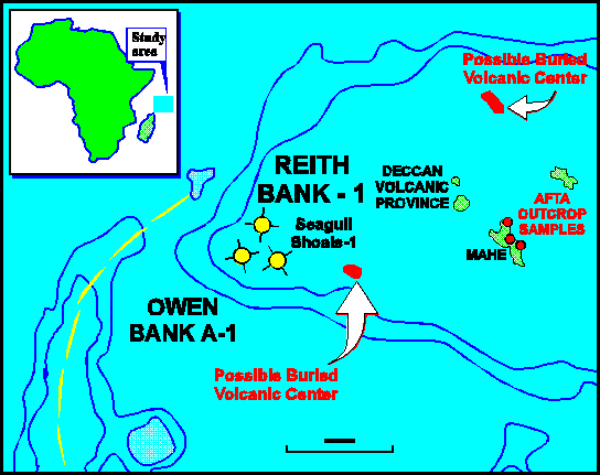
SEYCHELLES MICROCONTINENT
NON-EXCLUSIVE STUDYQUANTITIVE ASSESSMENT OF THE BURIAL, THERMAL AND HYDROCARBON GENERATION HISTORY USING AFTA® AND VITRINITE REFLECTANCE
with maturity modelling provided by Dr. Doug Waples
Background and Objectives
The Seychelles microcontinent covers an area of approximately 300,000 km2 within the western Indian Ocean, an area equivalent to the productive North Sea or the Texas/Louisiana Gulf Coast province. Until the Late Cretaceous, this microcontinent was sandwiched between northern Madagascar and the west coast of India; that is, between two giant tarsand fields and what became the Bombay High Offshore Oil Province.
In three of the four exploration wells drilled in the Seychelles, possible source rocks were encountered at several stratigraphic levels. Although relatively few source-rock analyses have been performed in the region, there is abundant evidence for the presence of effective source rocks. Some of the organic-rich horizons show evidence of having generated and expelled hydrocarbons. Minor hydrocarbon shows, plus gas sniffer and UV fluorescence anomalies, beach-stranded tars geochemically correlated to specific source rock horizons, and direct hydrocarbon indicators on seismic data all confirm a history of active hydrocarbon generation in the area. However, the present-day geothermal gradient and burial depth are insufficient to account for the measured organic maturities. Therefore, some of the key questions facing explorationists are:
- When were observed maturities reached? When was generation?
- Is there evidence for multiple periods of heating and cooling?
- What is the timing and magnitude of each of these episodes?
The Mesozoic geology of Seychelles evolved through three phases of rift/drift tectonics that included multiple periods of uplift, erosion and associated volcanism. The burial and thermal histories of the resultant sedimentary packages are therefore quite complex, and a thorough understanding of the relationship between time of generation and time of structuring is critical for a proper assessment of prospectivity.
Project details and techniques applied
AFTA® is used to identify, characterise and quantify the timing and magnitude of (multiple) thermal episodes. VR data is also used to constrain the magnitude of maximum paleotemperature. In combination, AFTA and VR are powerful tools which provide much needed constraint for rigorous basin models. Thermal history constraints provided by Geotrack will be employed by Dr. Doug Waples, an international recognised leader in basin modelling, to give a constrained basin model for the region and a framework within which the prospectivity of this frontier region can be confidently appraised.
The study includes samples from three offshore wells and three outcrop samples from Mahé. Nine AFTA samples and 13 new VR samples from the Reith Bank-1 well, together with 12 VR samples from the Owen Bank A-1 well are used to determine the paleogeothermal gradients and amounts of eroded section. Well data from Seagull Shoals-1 is interpreted in light of the new results and included in the regional synthesis. Finally, the new thermal history and basin modelling constraints are tied to and reconciled with seismic lines which cross the region. This project aims to provide the most detailed and comprehensive investigation of the thermal history that has yet been attempted in the region.
Objectives
- Identify, characterise and quantify the main paleothermal episodes (including estimates of maximum and peak paleotemperatures) with AFTA giving constraints on timing
- Calculate the paleogeothermal gradients during each episode
- Investigate the cause(s) of elevated paleotemperatures - e.g., burial prior to uplift and erosion, fluid movement, igneous activity
- Estimate the amount of section missing due to uplift and erosion
- Use the constrained thermal history derived from AFTA and VR to understand the history of source rock maturation and oil/gas generation
- Provide constrained basin models using existing wells and pseudo-well data from various depocentres within the Seychelles microcontinent
For further details please contact us